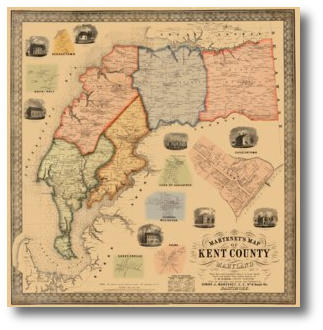
Martenet's 1860 Map of Kent County
Simon J. Martenet
Full Size: 35.3" x 34.4"About this Map
Our 1860 Kent County map features vignettes of prominent Kent County buildings as well as insets showing enlargements of Georgetown, Rock Hall, Chestertown, Head of Sassafras, Millington, Chesterville and Galena.
 |
(Click to enlarge) |
Click on the sample image to get a close up view of this map's detail.
This page concerns the map at full scale. Click on the link below to view the page for 2/3 scale:
(2/3) scale: (23.5" x 23") $95.00Contact us:
14 West Franklin StreetBaltimore, Maryland 21201
Phone: 410-539-4263
press@martenet.com